
Hollywood’s most famous adventurer Indiana Jones discovered the Lost Ark, the Holy Grail, and the Temple of Doom by painstakingly solving a series of clues, but his job would have been a lot easier if he’d had access to high-resolution satellite imagery.
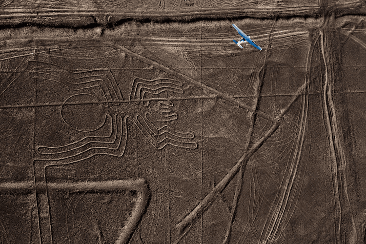
In the field of archaeology, you can see a great deal more from above than you can glimpse from ground-level. Ever since aerial photography was invented, archaeologists have launched hot air balloons, blimps, helicopters, and planes to take pictures of potential dig sites from the air.
It’s possible to spot clues from above such as unusual topography, anomalous plant growth, and (with the right camera) strange changes in the spectrum of soil. Even more can be seen from orbit – but only when satellites can capture ultra-high-resolution imagery.
Satellite-based imaging has recently evolved to the point where the pictures are sharp enough to reveal the sorts of details archaeologists are looking for. Image resolution that was once measured in feet is now measured in inches.
This technology – referred to as remote sensing – has resulted in an archaeological revolution, with thousands of major discoveries from the ancient world spotted from 450 miles above.
How Do Archaeologists Use Satellite Imagery?
Researchers use open-source and private satellite imagery including LIDAR, SAR, and InSAR technologies with thermal and infrared capabilities to look for subtle anomalies in areas of interest.
But it’s not just about scrolling through Google Earth in the hopes that you will stumble across an ancient ruin. Before looking at satellite imagery, archaeologists pinpoint potential sites by cross-referencing ancient and modern maps to examine topographical changes over time.
It’s also about common sense: for example, when looking for dig sites along the Nile, archaeologists narrow their search to higher ground because they know ancient cities would have been located on rises to avoid seasonal flooding.
When examining satellite data, researchers look for tell-tale signs such as:
- Differences in infrared wavelengths reflected by plants’ chlorophyll, which can reveal areas where plants are less healthy. Plants growing over buried structures are less vigorous than usual because their root systems are stunted.
- Moisture differences in surfaces (such as desert sand) above buried mudbrick.
- Frost lines that reveal buried ruins.
- The spectral signature of chemicals from certain types of ancient building materials bleeding into the soil.
Reassuringly, classic fieldwork still has a place in space-aged archaeology. Discoveries made by satellite are confirmed by visiting sites to core the earth or dig for artifacts in a process known as “ground-truthing.”
What Discoveries Have Been Made by Satellite?
The profession’s most famous space archaeologist, Sarah Parcak, has discovered thousands of ancient settlements and lost tombs in Egypt including over a dozen pyramids with the help of satellite imaging. Among her team’s most famous finds are the town grid of the lost city of Tanis, a ruined Roman amphitheater in Portus, an ancient Dacian city in modern-day Romania, and prehistoric hominid fossils in a Kenyan lakebed found using hyperspectral camera data. Parcak has found Viking sites in Newfoundland, a ceremonial platform in Petra, and has used satellites to create and update a countrywide looting map showing plundered tombs across Egypt.
Other space archaeologists have used satellite imagery to reveal Mayan causeways, roads, cisterns, and temples in the impenetrable jungles of northern Guatemala, a buried settlement including a pyramid near Cahuachi, Peru, and discovered a lost city in modern-day Oman known as Iram of the Pillars.


![LiDAR Expert Explains How the Technology Can Enforce Social Distancing Without Need for Staff Intervention [Interview]](/upload/20250615/i3hvyc0qq33.png)
![The Rise of Industrial Robots Operating in the U.S. Just Broke a Record [Report]](https://machinerys.net/upload/cache/202507/the-rise-of-industrial-robots-operating-in-the-u-s-just-broke-a-record-report.webp)