
As devastating as the Australian wildfires are, their impact could be even more catastrophic without recent technological advances.
Here are three forms of technology helping to map fires so first responders know where and how to best approach them, track smoke so scientists can study how the fires are affecting the entire planet, and aid in relief efforts.
1. Satellites
While firefighters and scientists can gather real-time information in land vehicles and airplanes, satellites provide a much broader scope of understanding of the fires.
NASA currently operates 26 satellites; Together, these satellites are known as the Earth Observing System (EOS). The EOS provides critical information on natural disasters to aid in the management and relief of the Australian wildfires.
NASA’s Worldview tool lets you interact with 900 full-resolution satellite imagery layers of the globe. Some of the images are posted within three hours of observation.
Suomi PP
NASA-NOAA’s Suomi National Polar-orbiting Partnership (NPP) satellite has been tracking weather since it was launched in 2011, and now it’s helping to track conditions of the Australia wildfires.
Suomi PP uses two instruments, OMPS-NM and VIIRS, to track the smoke emanating from the fires, which could have a devastating global impact. When the ash and smoke from the fire cools, they produce pyrocumulonimbus (pyrCbs) events that let smoke reach the stratosphere. After reaching sufficient altitude, the smoke can spread for thousands of miles. Not only has it darkened the snow on the mountaintops of nearby New Zealand, but on the other side of the world, smoke has turned the skies of South America hazy.
Ozone Mapping and Profiler Suite Nadir Mapper (OMPS-NM) is a backscattered UltraViolet (BUV) radiation sensor that can function even in thick cloud coverage. OMPS observes ozone layer health and measures ozone concentration within the Earth’s atmosphere. It offers an average data rate of 409,600 bps; nadir resolution mapper of 50 km; nadir resolution profiler of 250 km; and swath mapper of 2800 km. Scientists use the data from this instrument to track the aerosols and smoke using an ultraviolet aerosol index.
The Visible Infrared Imaging Radiometer Suite (VIIRS) does not offer the same detection capabilities, but it does give a “true-color” view of the smoke with visible imagery. With 22 imaging and radiometric bands, the Suite covers wavelengths of 0.41–12.5 microns and provides information in near real-time (NRT), which is critical so responders can act quickly. Among the more than twenty environmental data records it provides are aerosol, fire, polar wind, and vegetation. You can see an archive of the fire detection from VIIRS at the FIRMS Fire Map.
Aqua and Terra
NASA’s Aqua and Terra satellites carry the Moderate Resolution Imaging Spectroradiometer (MODIS). Every one to two days, it observes every point of Earth thanks to its 36 discrete spectral bands and 2,330-km-wide viewing swath; This makes it a go-to instrument for tracking large-scale deviations in the biosphere.
To gather information about how greenhouse gas is being absorbed, MODIS measures photosynthetic activity and can even predict weather conditions.
MODIS also records the distribution of cloud cover and measures the size of cloud droplets and aerosols, all critical factors for understanding wildfire conditions. The technology provides true-color imagery of the wildfires across a region and offers a stunning representation of what the situation looks like from above.
2. Artificial Intelligence
Satellite data is critical, but one of the downsides is that it still requires time for experienced personnel to search the imagery to identify changes in the wildfires. This is where artificial intelligence (AI) could offer a flicker of hope for wildfire management.
AUDREY
With money from the Department of Homeland Security Science and Technology Directorate, NASA Jet Propulsion Laboratory created a software application originally designed for space rovers: the Assistant for Understanding Data through Reasoning, Extraction, and sYnthesis (AUDREY). Though AUDREY is trained to aid firefighters on how to navigate in dangerous buildings, it may have additional applications in fighting the spread of wildfires.
AUDREY collects data, imagery, and sensor readings to provide situational awareness to first responders actively fighting fires. By analyzing video and sensor data, the technology tracks how quickly a fire is developing and how the contents of the fire could affect its growth. It can see through fire and smoke in ways that humans can’t.
Chooch AI
California-based Chooch AI is training its AI to identify wildfires based on complex satellite imagery. With the ability to see past clouds and smoke, it will also be able to determine which areas might be particularly susceptible to fires before they break out. The company is developing the trainable AI with researchers and technologists as well as state agencies.
Compta Emerging Business Solutions
Portuguese company Compta Emerging Business Solutions won IBM’s Watson Build Challenge at Think 2019 by developing a patented spectrometric analysis technology that can identify a wildfire within five minutes of it breaking out. The incredible speed at which it can detect fires could help personnel contain fires before they spread and cause more significant damage.
The technology is so advanced that it knows the difference between dust and smoke. Once a fire is detected, it processes the data it collects, such as wind speed, to forecast how it might spread and recommends a course of action to firefighters.
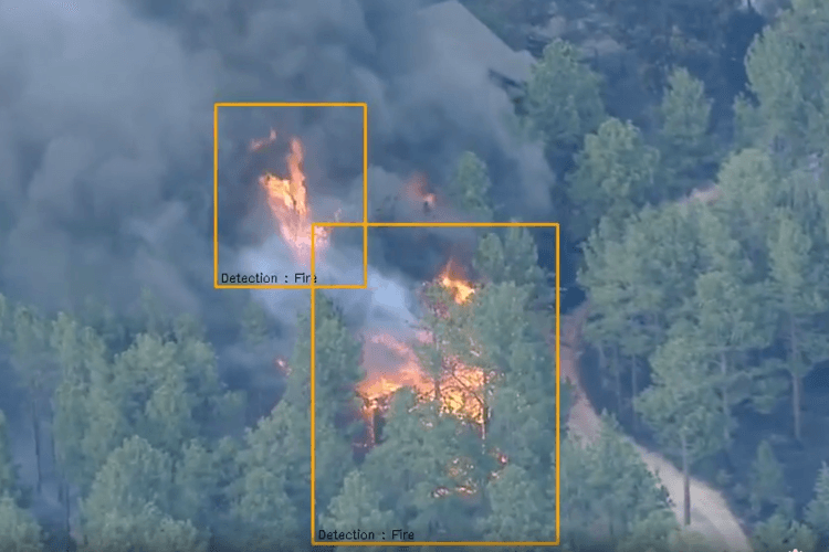
CrowdAI’s FireNet
California-based CrowdAI’s FireNet flies drones above wildfires to record imagery at 20 frames per second. The real-time data gets paired with GPS signals from the drone to determine the exact location of the fire. The AI has been trained to analyze this footage and identify a wildfire’s perimeter with as high as 92% accuracy as well as notice pattern deviations. This data is then used to create maps that instruct first responders where to go first to battle the blaze.
One Concern
After surviving the Kashmir flood of 2014, Ahmad Wani went on to meet AI specialist Nicole Hu and earthquake expert Tim Frank at Stanford University; Together they developed a platform called One Concern that combines AI with physical science to help those facing natural disasters.
By quantifying the impact of natural disasters, One Concern allows clients to assess their exposure to risk and the aftereffects of disasters. The platform allows users to share knowledge and coordinate efforts. Though its efforts are centered around floods and earthquakes, the platform has obvious wildfire applications. Being able to share time-sensitive, life-saving information is relevant not just for first responders but for those who live near common fires sites.
3. Drones
These unmanned aerial vehicles can be outfitted with mapping and surveying software to collect visuals of affected areas. First responders on the ground can use this data to determine where to best prioritize their efforts for aid, relief, and ultimately, reconstruction.
Robotto
The Danish Emergency Management Agency is collaborating with Robotto to create an autonomous drone that capitalizes on AI to measure wildfires.
An operator on the ground can use a handheld tablet to send the drone above the forest at a little over a mile high — significantly higher than many commercial drones — to locate a fire. There, it can change camera angles to get a proper understanding of the scope of the fire. The battery lasts for about two and a half hours, but the information captured by the drone can be sent back immediately through 5G.
DroneSeed
Drones have the powerful capability of being able to help with reforestation six times faster than hand planting. DroneSeed, for example, packs drones with up to 57 pounds of seeds and the software needed to spread the seed in the targeted areas where they will best flourish.